SAPRA
EN
PTPortuguêsENEnglishESEspañol

SAPRA, the warning inside the water
at the exact point of danger

Preventive Water Signage against Drowning and Accident Risks

The sea's danger almost never shows on the surface.
SAPRA takes the warning into the water
and shows, by the height of the tide, when the risk rises,
so you can decide before going in.

Signage that follows
the movement of the sea

For bathers and families

Watch the water. Check the band. Identify the hazard.The signal stands at the point of risk, visible from the sand and from the water, and works together with the flags, the signs and the lifeguard.

For lifeguards

More prevention, fewer rescues.The warning stays at the critical point at all times and reinforces the guidance given on the sand, even while the team is attending another incident.

For managers and partners

Survey, calibrate, operate.Each point is assessed by a water rescue team before it receives a signal, and is reassessed when the tide, the season or the seabed changes.

In the field

100%of the 125 bathers interviewed in Fernando de Noronha saw the signal in the water.

84%saw a flag on the sand. Author's field study, May 2026, preliminary result.

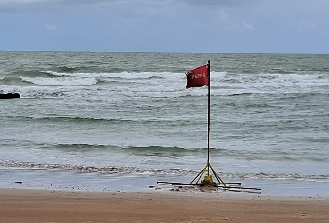
Signal pole with a red danger flag at the edge of a rough sea.

Video

SAPRA in under two minutes

A narrated animation that sums up the problem, how to read the pole and the four signals.

Narration in Portuguese. Captions, also in Portuguese, are available in the player.

How to read

The water is the pointer

The two-color pole stands in the water, next to the hazard. The band the water touches shows the risk at that point and at that moment.

  1. Watch the water. See how far up the pole it reaches.
  2. Check the band. Yellow means low to moderate risk. Red means high risk.
  3. Identify the hazard. The sign on the sand shows what is there.

How to read the two-color pole

Move the tide and see which band the water touches.

Pole with two color bands standing in the water. The water level shows the risk. limit set by the lifeguard water level
Low riskThe water touches the lower part of the yellow band. Low risk is not zero risk.
Type of hazard at this point

In a rip channel, the current gets stronger as the tide rises. That is why red is on top.

Why it matters

A danger you cannot see cannot be avoided

Signs and flags on the sand warn that there is danger, but rarely show where it is or what it is. People arrive at the beach, see calm water and go in.

300,000drowning deaths worldwide in 2021. More than 30 every hour.World Health Organization, 2024 global report
71,663drowning deaths in Brazil between 2010 and 2023. In 2023 alone there were 5,864.Brazilian Ministry of Health, 2025, and SOBRASA, Brazil Bulletin 2025
13,486of these victims were aged 14 or under. In this age group, 43% of deaths happened in natural waters.Brazilian Ministry of Health, Epidemiological Bulletin v. 56, no. 10
84% × 100%Of 125 bathers interviewed, 84% saw a flag on the sand. All of them saw the signal inside the water.Author's field study, Fernando de Noronha, May 2026. Preliminary result.

Natural traps

Know the hazard by its picture

Every place has its own hazard. See what it looks like, how to recognize it and what to do.

dark channel, no foam

Rip channel or rip current

What it is
A channel through which the water from the waves flows back out to sea, pulling anyone in it.
How to recognize it
A strip of darker, calmer water with no foam, between areas where the waves break.
What to do
Do not go in. If you are pulled out, do not swim against it: float, wave for help and swim sideways, parallel to the beach.
bottom disappears

Hole and drop-off

What it is
The bottom drops all at once. One step past knee-deep water and you can no longer stand.
How to recognize it
It almost never shows on the surface. That is why the signal stands in the water.
What to do
Go in slowly, feeling the bottom. Keep children within arm's reach.
passage with current

Reefs, rocks and reef gaps

What it is
Rock barriers that form pools at low tide. At the openings, the water runs fast when the tide flows over them.
How to recognize it
Rocks showing at low tide and water running between them.
What to do
Stay away from the openings and leave the pool before the tide covers the reefs.
high tide

Rising tide

What it is
The sea level rises and changes the place in a short time. Shallow becomes deep and the way back closes.
How to recognize it
The water advances over the sand, and sandbars and rocks start to disappear.
What to do
Check the tide table before leaving home and keep an eye on the band on the pole.
strong even in the shallows

Ground swell

What it is
Powerful waves formed far from the coast. They knock people down and drag them even in water below the knee.
How to recognize it
Sets of large, widely spaced waves with a strong backwash, even on a sunny day.
What to do
Stay out of the water and away from the rocks. Follow the lifeguard's instructions.

Marine animals

What it is
Areas with records of sharks, jellyfish or other animals that can injure.
How to recognize it
By the purple flag and the signs on the beach.
What to do
Respect the marked area and ask the lifeguard where bathing is allowed.

The system

Four signals at the point of danger

Each one suits a type of location. All of them stand at the point of danger and are installed after a lifeguard's assessment. The drawings explain how each one works. Real photos are in the gallery just below.

high risk low to moderate
Semi-fixed

Permanent reference on site

Two-color pole installed in the tidal zone, at points of constant risk. The water works as a pointer and shows the risk at that moment.

See real photos

water level
Semi-floating

Rises and falls with the water

Keeps the visual reference while the water level changes. Used where the tidal range or the shape of the seabed calls for controlled mobility.

See real photos

1 to 2 mchannelburied anchor weightropedo not go past
Floating

Warns that the danger is near

It floats on the water, 1 to 2 meters before the hole or rip channel, and follows the tide level. A rope tied to an anchor weight keeps the signal at that point, so it does not drift away. The weight is buried in the sand so nobody gets hurt.

Do not go near or past the signal.

See real photos

rises with the tide then back to the water's edge tide coming in sand
Swash-driven

Rises with the tide

It sits on the sand, on the line where the sea reaches. As the tide comes in, the swash (the small waves) pushes the signal out of the water, and it follows the advance of the sea up to the highest point of the tide. Then the lifeguard puts the signal back at the water's edge for the next cycle.

See real photos

This site explains what each signal communicates. Design, materials and installation are the responsibility of the author and the rescue teams.

Gallery

The signals in the field

Real photos of the models in use, from the author's archive. Choose a type to identify each signal and tap a photo to enlarge it and move from one to the next.

  • Semi-fixedTwo-color pole with a flag on top and its base resting on the sand. Fernando de Noronha.

  • Semi-floatingYellow pole with two floats and a danger flag.

  • Semi-floatingModel with a float and cross-shaped base, on dry sand.

  • Semi-floatingModel with one round float. Photographed on August 24, 2024.

  • Semi-floatingModel with cross-shaped base on wet sand.

  • FloatingFlag on a rod, floating in the sea. June 2026.

  • FloatingFloat with rod among the waves. May 2026.

  • FloatingFlag floating in rough sea.

  • Swash-drivenPole with danger flag on a cross-shaped base, on the sand.

  • Purple flagMarine animal warning on a floating base, at the water's edge.

Risk index

What each color means

No area of natural water is completely safe. The colors show the condition at that moment, and it changes during the day.

On SAPRA signals, inside the water

Two-color poleThe band the water touches shows the risk at that point. Yellow: low to moderate risk, which grows as the water level rises. Red: high risk. The position of the colors changes with the hazard at each location.

On lifeguard station flags

Red and yellowMarks the bathing area monitored and protected by the lifeguard.
GreenLow risk of drowning and more favorable conditions. Still requires attention.
YellowModerate risk. Watch out for waves, holes and rip currents.
RedHigh risk of drowning from strong waves or intense current.
Double redArea closed or extremely dangerous. Do not enter the water.
BlackStation closed or no lifeguard at that place or time.
PurpleDangerous marine animals present, such as jellyfish or Portuguese man o' war.
BlueLost person, such as a child or an elderly person, in the care of the station.

The use of flags may vary between states and beaches. If in doubt, ask the local lifeguard.

Identifying the hazard

Beyond color and word, the picture

A color or the word “danger” warns that there is a risk, but does not say which. SAPRA proposes flags with a picture of the hazard at that point, for those who do not know the color code, do not read Portuguese or cannot tell the colors apart.

The word alone

DANGER

Danger of what?

  • Drowning?
  • Rocks?
  • Shark?
  • Current?
  • Beach closed?

In the field study, 57% of the bathers who saw the flags on the sand perceived only a generic danger, without knowing which.

With a picture of the hazard

  • Rip currentThe water pulls out to sea at this point. Do not go in here.
  • Hole or drop-offThe bottom drops all at once. One step further and you cannot stand.
  • Rocks and reefsThere are rocks under the water. Risk of cuts and of current between them.
  • Strong wavesThe sea knocks you down and drags you, even in the shallows.
  • Marine animalsJellyfish, Portuguese man o' war or another animal that can injure.

The message repeated in four ways

  • Color: the level of risk, seen from afar.
  • Picture: the type of hazard, understood without reading.
  • Word: everyday language, in Portuguese and English.
  • Position: the flag stands at the point of danger, not far from it.

Who this makes a difference for

  • Tourists and children, who do not know what the colors mean.
  • Foreigners and people with limited reading.
  • People who have difficulty telling colors apart.
  • People with hearing loss, who cannot hear the whistle or the warning.

The pictures above are examples. The final set of illustrations is defined by the author and tested with the public before deployment.

Integrated prevention

One more layer, not a replacement

From the beach access to the water, bathers pass through several protections. SAPRA adds one of them, at the point of danger, and works together with the others.

  1. Signs at the accessThey show, before the sand, where the high-risk points are and which hazard exists at each one.
  2. Station flagsThey report the general condition of the sea that day and the area protected by the lifeguard.
  3. Guidance on the sandThe lifeguard's conversation with the bather explains what the signal means.
  4. Signal at the point of dangerThe SAPRA warning stands where the risk is, visible from the sand and from the water.
  5. Surveillance and rescueThe lifeguard watches, closes areas when needed and rescues.

The signal in the water does not replace the lifeguard, the official flag or the closing of areas.

For parents and bathers

I'm at the beach. Now what?

Ten steps, in the order they happen. Follow one at a time.

Before going in

  1. Look for the lifeguard and the flags.Always prefer the stretch with a lifeguard. Ask where it is best to stay.
  2. Read the local sign.It shows which hazard exists there: rip channel, hole, rocks or animals.
  3. Look at the water.Find the signal and see which band the water is touching.
  4. Choose where to go in.Stay away from the marked point. On red, do not go in.
  5. Been drinking? Stay on the sand.Alcohol dulls your reflexes and your sense of danger.

In the water

  1. Children always within arm's reach.Floats and life vests help, but do not replace an adult watching.
  2. Go in slowly, without diving head first.In an unfamiliar place, the bottom may be shallow or rocky.
  3. Do not go in alone.Tell someone on the sand and always stay in sight.
  4. Look again from time to time.The tide changes. What was yellow may turn red.
  5. Caught in a current? Do not swim against it.Stay calm, float, wave for help and swim sideways, parallel to the beach.

See someone drowning?

  1. Do not enter the water.People who try to rescue without training often become the second victim.
  2. Call the lifeguard and dial 193.Say where you are and point to the person, without taking your eyes off them.
  3. Throw something that floats.A float, a board, a foam box or a closed bottle, so they can hold on until help arrives.

For those coming from the congress

Evidence and references

What has been published, how the data were collected and what still needs validation. The figures on this page were checked against the sources indicated.

Publications and presentations

  • 2025. “Sinalização aquática na prevenção de afogamentos” (Water signage in drowning prevention). Proceedings of the XXIV SOBRASA Rescue, Fortaleza, October 15 and 18, p. S-88. Open the proceedings
  • 2026. “Sinalização aquática bicolor para prevenção de afogamentos: leitura dinâmica do alto e baixo risco relativo” (Two-color water signage for drowning prevention). Paper and poster, II CONABOM, Balneário Camboriú, November 25 to 27.

How to cite

AMARAL, Maximiliano do Nascimento. Sinalização aquática na prevenção de afogamentos. In: XXIV Campeonato e Simpósio Brasileiro de Salvamento Aquático, 2025, Fortaleza. Anais [...]. Rev Ed Física / J Phys Ed, suplemento, p. S-88.

Field study, Fernando de Noronha

Praia do Meio, May 18 to 23, 2026. Interviews with 125 bathers (45 men and 80 women), convenience sample.

Results of the field study at Praia do Meio
QuestionResult
Saw the signal inside the water125 of 125 (100%)
Saw at least one flag on the sand105 of 125 (84.0%)
Among the 105, identified the rip channel45 (42,9%)
Among the 105, perceived only a generic danger60 (57,1%)
Reported some swimming ability67 of 125 (53.6%)

Experiment in Olinda

From October to December 2024, at Stations 1 and 3. The proceedings record 32 drownings in 2023 and 5 in 2024. The study had no comparison group.

General data used on the site

What has not yet been demonstrated

  • The results are descriptive. Seeing the signal does not prove spontaneous understanding, a change in behavior or a reduction in drownings.
  • Understanding of the colors was observed after guidance, with no before-and-after measurement.
  • A visual range of 500 m, night-time reading and a percentage reduction in incidents are validation targets.
  • Next step proposed by the author: a prospective study at several sites, with protocol, comparison areas and statistical analysis defined before data collection.

The project

From Olinda to other waters

SAPRA was born from the routine of a lifeguard facing drownings that kept happening at the same points, even with signs, flags and surveillance.

  1. First experiment. From October to December, the water signal flag is tested at two lifeguard stations in Olinda, Pernambuco.
  2. XXIV SOBRASA Rescue. The work is presented at the Brazilian Water Rescue Symposium, in Fortaleza, on October 15 and 18, and published in the event's proceedings.
  3. Field study. Perception survey with 125 bathers at Praia do Meio, in Fernando de Noronha.
  4. Two-color pole. Reading high and low risk by the water level is described in a scientific paper.
Preliminary result. At Stations 1 and 3 in Olinda, the proceedings of the XXIV SOBRASA Rescue (p. S-88) record 32 drownings in 2023 and 5 in 2024, the year of the experiment, a reduction of 84%. The study had no comparison group, so the figure points to a direction and still needs validation.

Where it applies today

  • Beaches with rip channels and rip currents
  • Beaches with reefs, reef gaps and rocks
  • Stretches with holes and drop-offs
  • Islands with ground swell

Where it could go

  • Rivers with current and changing levels
  • Lakes and reservoirs with uneven bottoms
  • Estuaries and tidal areas

Applications under study. Each environment requires its own assessment and calibration.

The system follows an environment that changes: tide, season, storm surges and the shifting of rip channels and sandbars. That is why each point is reassessed and the signal is repositioned when the place changes.

For city halls, fire and rescue services and partners

How the signal reaches a location

No point receives a signal without technical assessment. Deployment follows four stages, led by a water rescue team.

  1. SurveySurvey of tide, waves, currents, seabed relief and bather movement.
  2. CalibrationSetting the limit of each color band for the hazard at that point.
  3. Warning on landSign with a picture of the hazard and plain language, in Portuguese and English.
  4. OperationTeam training, inspection and recalibration after storm surges or changes at the site.

Frequently asked questions

Questions from people on the sand

Does yellow mean I can go in?

On the signal inside the water, yellow indicates low to moderate risk at that point and at that moment, and the risk grows as the water rises up the band. It is not the absence of risk. Go in with care, near the lifeguard, and keep watching the pole.

Does the signal replace the lifeguard or the beach flag?

No. It complements both. The flag reports the general condition of the sea, the signal in the water shows where the danger is, and the lifeguard guides and rescues.

Why does the position of the colors change from place to place?

Because each hazard behaves differently. In a rip channel, the risk grows at high tide. Next to a hole, it can be the opposite. Each pole is calibrated by the lifeguard, and the sign on the sand explains the local hazard.

What if the beach has no signal in the water?

Look for the stretch with a lifeguard, respect flags and signs and ask where it is best to stay. If in doubt, do not go in.

Does it work at night?

The signal stays in place at all times, but night-time reading is still being validated. At night, do not go into the sea.

Does it work for rivers, lakes and reservoirs?

The principle is the same: put the warning at the point of danger. These applications are under study, and each environment requires its own assessment and calibration.
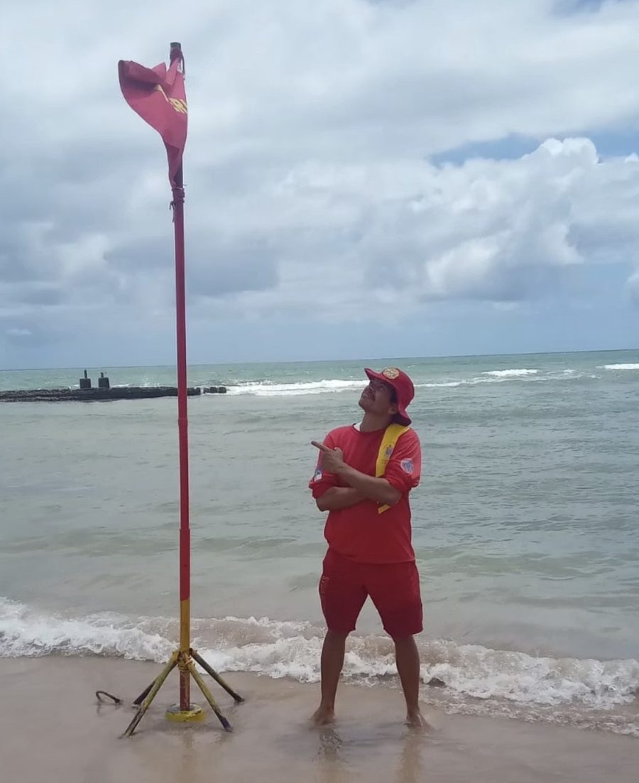
Maximiliano do Nascimento Amaral, in lifeguard uniform, beside a signal pole at the water's edge.
The author beside the signal, on November 28, 2024.

Authorship

Maximiliano do Nascimento Amaral

Lifeguard in Pernambuco, Brazil, creator of the water signage system presented on this site and author of the studies that describe it.

Partnerships, deployment and press:
maxnascimento1980@gmail.com

Photo of João Guilherme Gomes de Araújo.

Website and video

João Guilherme Gomes de Araújo

Developer of this website and responsible for creating and editing the video. Founder of ClairiX, a company that builds systems, websites, apps and other digital solutions.

To see the work or get in touch, use the links below.

Before going into the sea, watch the water,
check the band and identify the hazard.
If in doubt, stay on the sand and look for the lifeguard.

Emergency in Brazil: call 193